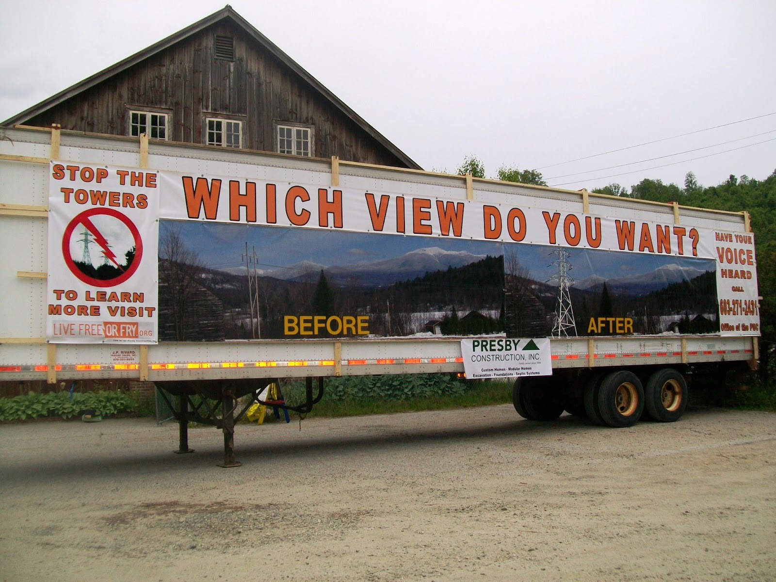
I am opposed to NP's current proposal to carve a
path of unsightly and quite possibly unhealthy HV
towers thru Northern NH. This will blight the
landscape and affect not just the many unfortunate
people who abut it or see it, but all citizens of NH.
towers thru Northern NH. This will blight the
landscape and affect not just the many unfortunate
people who abut it or see it, but all citizens of NH.
I worked as a pediatrician in Plymouth for 15 years,
during which time we experienced a cluster of
childhood cancers in an area close to high voltage
power lines. Although the government agency sent
to investigate could neither prove nor disprove
causation, parents were not soothed. There are
certainly enough questions left about these HV lines
that I would never advise a parent to buy a house
close to one, and frankly, they don't need to be told
by me - they reach their own conclusions.
Watch real estate prices drop, then watch a corresponding
drop in business profits from primary and second
home buyers and tourism. Watch towns around NH,
largely dependent on property taxes to fund
education, grapple with the short fall. This project
has a net negative impact, except for the balance
sheets of PSNH and HQ.
drop in business profits from primary and second
home buyers and tourism. Watch towns around NH,
largely dependent on property taxes to fund
education, grapple with the short fall. This project
has a net negative impact, except for the balance
sheets of PSNH and HQ.
I would also like to object to the distinction being made between
cutting through new property and using existing ROWs for
these towers. Both are deplorable, but more
attention is being paid to ruining virgin land. I wish
to point out, however, that the existing ROWs in
question have been around from the 40s, with
wooden poles that do not rise above the tree line.
these towers. Both are deplorable, but more
attention is being paid to ruining virgin land. I wish
to point out, however, that the existing ROWs in
question have been around from the 40s, with
wooden poles that do not rise above the tree line.
Previous approval for this does not mean that
existing ROWs should be treated as a ''given'' that
can be done with as PSNH pleases. They will
definitely have to be widened, the towers will affect
the surrounding homes in an entirely new way.
existing ROWs should be treated as a ''given'' that
can be done with as PSNH pleases. They will
definitely have to be widened, the towers will affect
the surrounding homes in an entirely new way.
If this is permitted, people will understand that any
ROW in any area of the state is not safe to buy near.
Again, watch the real estate and thus the tax base
all over NH suffer as potential home owners realize
that no one in their government will protect them
from private industry, foreign and domestic.
ROW in any area of the state is not safe to buy near.
Again, watch the real estate and thus the tax base
all over NH suffer as potential home owners realize
that no one in their government will protect them
from private industry, foreign and domestic.
If PSNH wants the tremendous revenue THEY will
receive from leasing the existing ROWs, they need
to bury the lines to protect the quality of life in NH.
If that's "too expensive" that is their problem, not the
receive from leasing the existing ROWs, they need
to bury the lines to protect the quality of life in NH.
If that's "too expensive" that is their problem, not the
citizens of NH.
--------------------------------------------------------------------------------------
On May 5, 2004, the Connecticut State Senate passed HB 5418 requiring burial of high voltage lines near residential areas and schools, daycare centers, playgrounds and other areas where children congregate. Human health and safety concerns along Connecticut Light & Power's and United Illuminating's proposed 69-mile Norwalk-to-Middleton upgrade motivated this legislative action. Owned by Northeast Utilities, CL&P and UI initially complained that burial was "too expensive," but the utility developers found a way to overcome their earlier objections.
If HV undergrounding is necessary to protect human health in Connecticut, home state of PSNH's parent company NU, why not in New Hampshire?