Thursday, June 30, 2011

"To the extent possible": Northern Pass's Conditional Environmentalism

In the abstract, Northern Pass talks with great certitude about its commitment to the environment. On the ground, it speaks with less conviction, as this sampling of conditional statements from Northern Pass's Special Use Permit application to construct an HVDC power line in the White Mountain National Forest illustrates (emphases added).


  • Along the entire length of the Northern Pass Transmission Line, Northern Pass has attempted to design the Project to minimize environmental and other impacts as much as practicable . . . (1).
  • Care would be taken to maintain vegetation along stream banks and within wetlands to the extent possible (3).
  • As much as possible, the Northern Pass will locate [temporary work areas between 2 and 5 acres] outside of the WMNF (4).
  • Routes other than those seriously considered were deemed unreasonable based on increased social or environmental impacts or excessive costs (5).
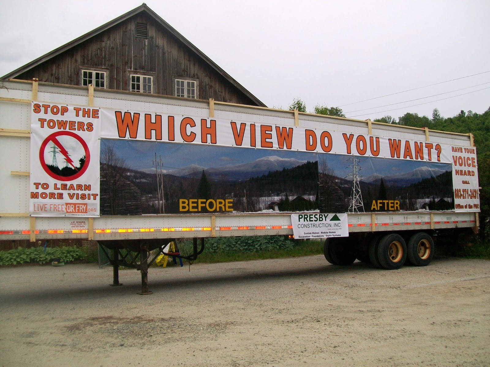
  • Northern Pass will work with the Forest Service and other interested parties to develop an approach that minimizes visual impacts to the extent practicable (10).
  • Northern Pass will design the transmission structures, temporary work areas, and temporary access roads to avoid and minimize impacts to wetlands wherever possible (11).
  • Northern Pass--in order to minimize impacts to the WMNF--is seeking to the extent possible to locate the Northern Pass Transmission Line within the existing transmission corridor in the WMNF, which is 150' wide (2).
  • Where practical, trees would be felled parallel to and within the corridor to minimize the potential for off-corridor vegetation damage (3).
  • The major factors in the routing were designed to minimize impacts to the extent practicable . . . (6).

The verb "minimize," as in "to minimize environmental impacts," occurs some 24 times in 13 pages of the SUP application.

To minimize, v., a. To reduce to the smallest possible amount, extent, size, or degree.

Building the transmission line is Northern Pass's top priority. Minimizing environmental, human, and other harm is incidental -- to the extent possible and where practical.

Thursday, June 23, 2011

Childhood Cancer Cluster near High Voltage Lines in Plymouth NH

The following is a scoping comment entered on the DOE EIS site on June 14, 2011 by Robert C. Hoyer, M.D., a pediatrician who practiced in Plymouth NH for 15 years.

I am opposed to NP's current proposal to carve a
path of unsightly and quite possibly unhealthy HV
towers thru Northern NH. This will blight the
landscape and affect not just the many unfortunate
people who abut it or see it, but all citizens of NH.

I worked as a pediatrician in Plymouth for 15 years,
during which time we experienced a cluster of
childhood cancers in an area close to high voltage
power lines. Although the government agency sent
to investigate could neither prove nor disprove
causation, parents were not soothed. There are
certainly enough questions left about these HV lines
that I would never advise a parent to buy a house
close to one, and frankly, they don't need to be told
by me - they reach their own conclusions.

Watch real estate prices drop, then watch a corresponding
drop in business profits from primary and second
home buyers and tourism. Watch towns around NH,
largely dependent on property taxes to fund
education, grapple with the short fall. This project
has a net negative impact, except for the balance
sheets of PSNH and HQ.

I would also like to object to the distinction being made between
cutting through new property and using existing ROWs for
these towers. Both are deplorable, but more
attention is being paid to ruining virgin land. I wish
to point out, however, that the existing ROWs in
question have been around from the 40s, with
wooden poles that do not rise above the tree line.
Previous approval for this does not mean that
existing ROWs should be treated as a ''given'' that
can be done with as PSNH pleases. They will
definitely have to be widened, the towers will affect
the surrounding homes in an entirely new way.

If this is permitted, people will understand that any
ROW in any area of the state is not safe to buy near.
Again, watch the real estate and thus the tax base
all over NH suffer as potential home owners realize
that no one in their government will protect them
from private industry, foreign and domestic.

If PSNH wants the tremendous revenue THEY will
receive from leasing the existing ROWs, they need
to bury the lines to protect the quality of life in NH.
If that's "too expensive" that is their problem, not the
citizens of NH.

--------------------------------------------------------------------------------------

On May 5, 2004, the Connecticut State Senate passed HB 5418 requiring burial of high voltage lines near residential areas and schools, daycare centers, playgrounds and other areas where children congregate. Human health and safety concerns along Connecticut Light & Power's and United Illuminating's proposed 69-mile Norwalk-to-Middleton upgrade motivated this legislative action. Owned by Northeast Utilities, CL&P and UI initially complained that burial was "too expensive," but the utility developers found a way to overcome their earlier objections.  


If HV undergrounding is necessary to protect human health in Connecticut, home state of PSNH's parent company NU, why not in New Hampshire?

Keep on Truckin'


Located on Main Street, Franconia, across from Garnet Hill courtesy of the Presby Brothers Construction

The current view from Streeter Pond Road across Bode Miller's Turtle Ridge Farm to Mt. Lafayette
Which view do you want?

Friday, June 17, 2011

The Biggest Land Grab in New Hampshire History

On its new website uploaded late this Friday afternoon, Northern Pass reveals what would be the biggest land grab in New Hampshire history. From Deerfield to Pittsburg, private property would have to be taken for a project with no public need or justification.

Of the 31 towns and cities on the proposed route, 21 would see the taking of land by eminent domain either to create a new right of way or to "expand" an existing right of way (ROW). Eight towns would be scarred with entirely new ROWs; thirteen towns would have existing ROWs "expanded" beyond current widths to accommodate the proposed HVDC line, which would be added alongside one or two HVAC lines. ("Expanded" is NP's term.)

In reality, both situations represent new ROWs. The difference between them is simply whether the new ROW would be created to abut an existing ROW or not. It doesn't matter whether 10', 25', 50' or 250' is taken if your house or land is seized by eminent domain. PSNH has no inherent right to "expand" their ROWs. The easement deeds do not contain blanket permission for PSNH to come back and take more land whenever it wants it. PSNH would have to condemn and take the additional private property by eminent domain.

For instance, PSNH states that over five miles of the seven mile ROW in Deerfield would have to be "expanded" by an unspecified amount. This information is oddly phrased to suggest that the "expansion" would somehow occur within the existing ROW. It would (could) not. The new ROW of unspecified width would run alongside the current ROW. It also implies that PSNH has the right to "expand" its ROW. It does not. PSNH would have to take private property to create a new ROW to abut their existing one.

Northern Pass website: "Community" page for Deerfield
 Northern Pass is proposing an eminent domain nightmare.

Further, the highest towers are proposed for two towns that host the White Mountain National Forest, the National Scenic Appalachian Trail (AT), and the lower part of Franconia Notch State Park: Lincoln and Easton. These mammoth towers will cross the AT, run close to South Kinsman, a popular hiking destination on the AMC's Four Thousand Footer list, and be visible from the I-93 gateway approach.

Northern Pass is proposing an outrage to federal and state scenic treasures.

Towns that would see private property seized by eminent domain to create new ROWs of unspecified widths that do not abut current ROWs: Chichester, Clarksville, Colebrook, Columbia, Northumberland, Pittsburg, Stewartstown, Stratford.

(Clarksville, Colebrook, Columbia, Pittsburg, Stewartstown, and Stratford carry the note that "this route is not final; project representatives are working with landowners and town officials to reevaluate certain segments of the preferred route, and to explore whether there might be other feasible routing options—particularly in the North Country—that could achieve broader community support." This is the so-called Plan B through the large land holdings in eastern Coos County that NP has unsuccessfully been trying to negotiate for months.)

Towns that would see private property seized by eminent domain to create new ROWs of unspecified widths that do abut current ROWs: Allenstown, Bethlehem, Bridgewater, Campton, Canterbury, Concord, Deerfield, Franklin, Hill, New Hampton, Northfield, Pembroke, Woodstock.

In all, of the 180 mile proposed route, 73 miles (40%) would see new ROWs.

For the "most common tower height" in each town, whatever that may mean, and for details about the lengths (but not the widths) of abutting and non-abutting new ROWs, see: http://northernpass.us/communities.

PSNH has repeatedly said that it would use eminent domain only rarely and as a last resort for this project. How does that square with the facts that NP has just announced: 21 towns and cities in NH would see private property seized by eminent domain for new abutting and non-abutting ROWs? How does PSNH's reassurance fit with the fact that it plans to take 73 miles of new ROWs of unspecified widths? How many hundreds of NH property owners will be deprived of their basic rights in order to support a private utility developer who said just two weeks earlier that HB 648 legislation was not necessary to protect them from such land seizure?

Friday, June 3, 2011

HB 648 Roll Call Vote in the Senate (June 2, 2011)

Compiled by an Opposition member from a political family. This is the kind of analysis that begins the Morning After and continues until the next election.


Voting NO on 648 (and thereby for the Forrester eminent domain moratorium amendment and with the Opposition):

Gallus                 (R) District 01    
Forrester             (R) District 02
Forsythe              (R) District 04
Groen                  (R) District 06
Sanborn               (R) District 07
White                  (R) District 09
Bragdon              (R) District 11
Lambert              (R) District 13
Barnes                (R) District 17
Prescott              (R) District 23

Voting YES on 648 (and thereby against the Forrester eminent domain moratorium amendment and against the Opposition):
Bradley                 (R) District 03    
Houde                   (D) District 05    
O’Dell                   (R) District 08
Kelly                      (D) District 10
Luther                    (R) District 12
Carson                   (R) District 14
Larsen                   (D) District 15
Boutin                   (R) District 16
DeBlois                 (R) District 18
Rausch                  (R) District 19
D’Allesandro         (D) District 20
Merrill                   (D) District 21
Morse                    (R) District 22
Stiles                      (R) District 24

Senate District 3 comprises: Brookfield, Chatham, Conway, Eaton, Effingham, Farmington, Freedom, Madison, Middleton, Milton, Moultonborough, Ossipee, Sandwich, Tamworth, Tuftonboro, Wakefield and Wolfeboro.
Senate District 5 comprises: Andover, Cornish, Croydon, Danbury, Enfield, Franklin, Grafton, Grantham, Hanover, Hill, Lebanon, Plainfield, Springfield and Wilmot.
Senate District 8 comprises: Acworth, Alstead, Charlestown, Claremont, Gilsum, Goshen, Langdon, Lempster, Marlow, New London, Newbury, Newport, Roxbury, Stoddard, Sullivan, Sunapee, Sutton, Unity, Walpole, Washington and Westmoreland.
Senate District 10 Comprises: Chesterfield, Dublin, Fitzwilliam, Hinsdale, Keene, Marlborough, Richmond, Surry, Swanzey, Troy and Winchester.
Senate District 12 comprises: Brookline, Hollis, Mason, and Wards 1, 2, 5, and 9 in the city of Nashua.
Senate District 14 comprises: Wards 3, 4, 6, 7 and 8 in the city of Nashua.
Senate District 15 comprises: Concord, Hopkinton and Pembroke.
Senate District 16 comprises: Bow, Candia, Dunbarton, Hooksett and Wards 1, 2 and 12 in the city of Manchester.
Senate District 18 comprises: Litchfield and Wards 5, 6, 7, 8 and 9 in the City of Manchester.
Senate District 19 comprises: Derry, Hampstead and Windham.
Senate District 20 comprises: Goffstown and Wards 3, 4, 10 and 11 in the City of Manchester.
Senate District 21 comprises: Dover, Durham, Epping, Lee and Rollinsford.
Senate District 22 comprises: Atkinson, Pelham, Plaistow and Salem.
Senate District 24 comprises: Greenland, Hampton, Hampton Falls, New Castle, Newington, North Hampton, Portsmouth and Rye.

Wednesday, June 1, 2011

The 25th Senator?

The Honorable Richard Samson, Opposition District 1, Coos County

State Capitol Plaza, Concord, June 1, 2001